Via Aurelia Rome: Ancient Coastal Road, Janiculum and Western Rome
Via Aurelia Rome is one of the best ways to understand Rome as a living archaeological landscape rather than a collection of isolated monuments. The ancient road linked the city with the Tyrrhenian coast northwest of Rome, eventually linking with Etruscan and Tuscan routes, and its line still shapes modern streets, neighborhoods, bridges, gates and archaeological sites.
This 2026 guide explains where the Via Aurelia ran, why it mattered, what survives today and how to trace the most interesting sections without turning the day into a transport marathon. Some monuments along the route have limited access, restoration closures or special-opening schedules, so use the official source linked below shortly before visiting.
Via Aurelia Rome at a glance
| Direction | West and northwest from Rome |
| Landscape | Janiculum, Aurelia Antica and coastal corridor |
| Major park context | Villa Doria Pamphilj |
| Roman station | Lorium at Castel di Guido |
| Notable archaeology | Mausoleum and villa remains at Castel di Guido |
| Best for | Road history combined with parks and western Rome |
Why the Via Aurelia matters
The Via Aurelia was one of Rome’s major roads toward the Tyrrhenian coast. Built and extended during the Republican expansion into Etruscan territory, it eventually formed part of a long coastal network connecting Rome with settlements to the northwest.
The precise urban approach evolved over time, but the road’s western direction is preserved in the Via Aurelia Antica and modern Via Aurelia. The corridor passed near the Janiculum and then across a landscape of villas, cemeteries, farms and later Christian sites.
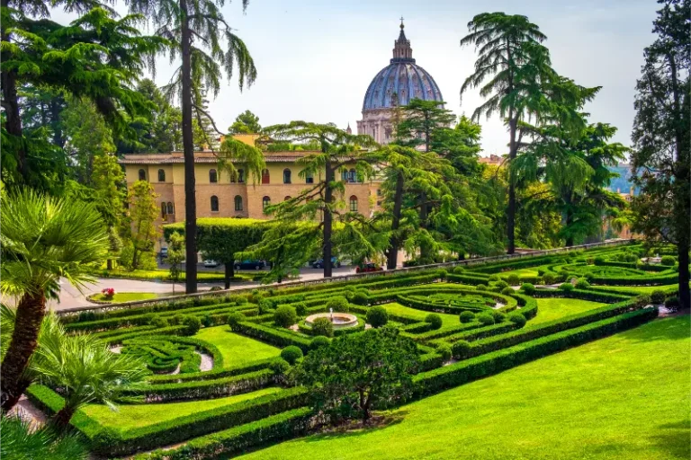
Villa Doria Pamphilj preserves important evidence for this suburban environment. Ancient funerary structures and the line of the Trajan-Paul aqueduct system coexist with the later baroque park, demonstrating how Roman infrastructure remained embedded in elite landscapes.
Farther west, Castel di Guido corresponds to the Roman station of Lorium at approximately the twelfth mile. Imperial villas and service facilities developed around the road, and Antoninus Pius had strong associations with the area. This makes the outer Aurelia much more than a highway to the coast.
Where the ancient road ran
From the western side of ancient Rome, the Aurelia corridor climbed toward the Janiculum and continued along the line now called Via Aurelia Antica. The modern road later shifted and widened, but the ancient direction remains legible.
Villa Pamphilj occupies a large section of the historical suburban landscape. The park’s northern boundary and surrounding streets preserve traces of ancient water and road infrastructure, even where the road itself is no longer visible as paving.
Beyond the dense city, the road continued through what is now Castel di Guido toward the coast. For a visitor, this outer extension is best treated as a separate excursion, especially if you want to investigate Lorium and rural archaeology.
Roman roads were not immutable lines drawn once and preserved forever. Approaches to the city changed when walls, bridges and gates were rebuilt; later roads often shifted a few meters from the ancient alignment; medieval and modern construction reused paving and masonry. For visitors, the goal is therefore not to imagine that every modern lane sits exactly on Roman basalt, but to recognize a corridor that remained strategically important for centuries.
Best places to trace the road today
Janiculum and Porta San Pancrazio area
Begin high on the western side of Rome, where roads leaving Trastevere and the Janiculum connected with the Aurelia corridor. The gate visible today is later than the ancient route, but the topography explains how travelers climbed out of the city toward the west.

Via Aurelia Antica
This road preserves the name and direction of the historical route. Much of the visible environment is later, yet the corridor is valuable for understanding continuity of movement through western Rome.
Villa Doria Pamphilj
Rome’s largest landscaped park contains archaeological traces, ancient funerary structures and the line of the Trajan-Paul aqueduct system near the Aurelia Antica. It is the most pleasant place to experience the road landscape without traffic.
Casale and Mausoleum of Castel di Guido
At the outer edge of Rome, Castel di Guido preserves remains connected with Lorium, a Roman station on the Aurelia. The hypogeal mausoleum beneath the Church of the Holy Spirit is a particularly important survival, although access may require prior arrangement.
The road toward the Tyrrhenian coast
Beyond Castel di Guido, the Aurelia continues toward coastal Etruria. Even if you do not follow it farther, understanding that direction explains why the road later became one of the principal western exits from modern Rome.
A practical self-guided route
1. Start at the Janiculum
Use the viewpoint and Porta San Pancrazio area to orient yourself geographically toward western Rome.
2. Enter Villa Doria Pamphilj
Spend at least an hour walking the park and looking for archaeological context along the Aurelia Antica edge.
3. Continue along Via Aurelia Antica
Use a bus for longer stretches and notice how the road corridor remains distinct from the newer highway-like Via Aurelia.
4. Optional: go to Castel di Guido
This extension is best with a car or carefully planned bus trip. Check access conditions for archaeological sites before leaving.
5. Finish with the landscape, not a checklist
The Aurelia is strongest as a story of geography, estates and movement toward the coast rather than as a sequence of famous ruins.
Allow roughly 3–4 hours for the city section; half a day more for Castel di Guido for the core route. You can shorten it by choosing only the first two or three stops, or expand it into a full day by adding the nearby museums, churches and parks mentioned in the internal links. The route is more enjoyable when you leave time to look at the urban fabric instead of treating every stop as a checklist item.
How to read what survives
The Aurelia teaches a different kind of road archaeology. Instead of a continuous paved line, you read direction through topography, surviving place names, villa landscapes and archaeological nodes.
At Villa Pamphilj, later baroque design can make visitors forget the ancient layers. Look for reused materials, funerary areas and aqueduct structures that reveal the park was never an empty countryside canvas.
At Castel di Guido, the concept of a road station becomes tangible. Major Roman roads required places for rest, changing horses, administration and supply; settlements grew around those needs.
Practical visiting information for 2026
| Best city start | Janiculum / Porta San Pancrazio |
| Main green stop | Villa Doria Pamphilj |
| Outer archaeological zone | Castel di Guido / Lorium |
| Park cost | Free |
| Best transport | Walking in the park, bus or car for outer Aurelia |
Villa Doria Pamphilj is the most visitor-friendly part of this route and can easily fill two hours. Park gates and internal routes are extensive, so choose an entrance that supports your overall direction.
Castel di Guido is not a standard walk-in museum stop. Official information notes that the hypogeal mausoleum can be visited on request, so confirm arrangements before traveling specifically for it.
Traffic on the modern Via Aurelia is heavy. Avoid treating the main highway as a walking route; use the Aurelia Antica, parks and archaeological nodes instead.
For the latest access information, check the official Turismo Roma page for Castel di Guido. Official pages are especially important for monuments that open only on selected dates, require guided access or may close temporarily for conservation work.
How to get there and move between the stops
Buses connect the historic center and western neighborhoods with the Aurelia area, while Villa Pamphilj has multiple access points served by different lines.
For Castel di Guido, a car is the simplest option. Public transport is possible but slower and less flexible, especially if you need to coordinate a special archaeological visit.
If you are continuing toward the coast or Fiumicino area, treat that as a separate travel day rather than trying to extend the archaeological walk indefinitely.
What to see nearby
Combine the urban section with Villa Doria Pamphilj and Janiculum Hill. These give the route stronger viewpoints, green space and practical context.

Photography tips
Villa Pamphilj is the best photographic environment on this route. Use long views through trees and paths to suggest the scale of the suburban landscape, then add a tighter archaeological detail for contrast. Ancient road sites often look modest at first glance, so side light, a human figure for scale and a wider view that includes the modern city can tell the story better than a tight photograph of masonry alone.
At roadside monuments, never step into traffic lanes or climb barriers for a photograph. A telephoto lens or phone zoom is often safer and more useful than trying to stand directly beside a monument that was never designed as a modern visitor attraction.
Accessibility and comfort
Major Villa Pamphilj paths are relatively easy, but slopes, gravel and long distances matter for mobility-limited visitors. Castel di Guido requires advance planning and may not offer fully step-free archaeological access.
Carry water in warm months, wear shoes with reliable grip and avoid assuming that a short distance on the map will be comfortable in summer heat. Rome can be demanding in July and August, while heavy rain can make park paths muddy and expose uneven paving.
Common mistakes to avoid
- Walking along the modern high-speed Aurelia instead of using parks and quieter historical segments.
- Expecting a continuous preserved Roman pavement.
- Visiting Castel di Guido without arranging access.
- Underestimating the size of Villa Pamphilj.
- Treating the Janiculum as the destination rather than as geographic orientation for the road west.
FAQ about Via Aurelia Rome
Where did the Via Aurelia go?
It ran west and northwest from Rome along the Tyrrhenian side of Italy, eventually connecting with routes toward Etruria and Tuscany.
Can you see the ancient Via Aurelia in central Rome?
The road is more difficult to see as continuous ancient paving than the Appian Way, but its corridor survives through Via Aurelia Antica and western archaeological sites.
Is Villa Pamphilj part of the route?
The park occupies the historical suburban landscape along the Aurelia Antica and preserves Roman archaeological traces, making it an excellent contextual stop.
What was Lorium?
Lorium was a Roman station and settlement along the Aurelia near modern Castel di Guido, associated with imperial properties.
Is the route good without a car?
Yes for the Janiculum and Villa Pamphilj section. A car becomes much more useful if you want to extend to Castel di Guido.
Final tips
The Via Aurelia is a landscape road. Its story survives in a westward climb, a historic corridor, a huge park, suburban archaeology and the station of Lorium rather than in one famous paved stretch. That makes it ideal for travelers who want to understand how roads organized Rome’s countryside as well as its monuments.